


Locus SIG Arpentage hors ligne
Description de Locus SIG Arpentage hors ligne
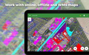
Application SIG professionnelle pour le travail de terrain hors ligne avec des géodonnées. Elle permet la collecte, la visualisation et l'inspection des données, ainsi que la connexion à des unités GNSS externes d'une précision centimétrique fournie par un client NTRIP. Toutes ses fonctionnalités sont disponibles au-dessus d'une large sélection de cartes en ligne, hors ligne et WMS/WMTS.
Travail sur le terrain
- Collecte et mise à jour hors ligne des données de terrain
- Sauvegarde de points avec l'emplacement actuel, par moyenne d'emplacement, projection, coordonnées et autres méthodes
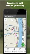
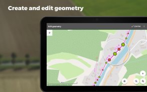
- Création de lignes et de polygones par enregistrement de mouvements
- Paramétrage des attributs
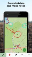
- Photos, vidéo/audio ou dessins en pièces jointes
- Définition des points
- Délimitation des frontières
Importation/Exportation
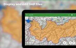
- Importer et éditer des fichiers ESRI SHP
- Exportation de données vers des fichiers ESRI SHP ou CSV
- Exportation de projets entiers vers QGIS
- Prise en charge du stockage dans le nuage de tiers (Dropbox, Google Drive et OneDrive)
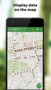
Cartes
- Large gamme de cartes à utiliser en ligne ou à télécharger
- Prise en charge des sources WMS/WMTS
- Prise en charge des cartes hors ligne aux formats MBTiles, SQLite, MapsForge, ainsi que des données OpenStreetMap ou des thèmes cartographiques personnalisés.
Outils et fonctionnalités
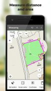
- Mesure des distances et des surfaces
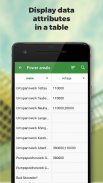
- Recherche et filtrage des données dans la table d'attributs
- Édition de style et étiquettes de texte
- Style conditionnel - style unifié basé sur les couches ou style basé sur des règles dépendant d'une valeur d'attribut
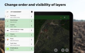
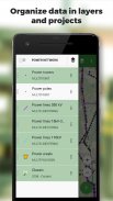
- Organisation des données en couches et en projets
- Modèles pour l'établissement rapide d'un projet, de ses couches et de ses attributs
- Prise en charge de plus de 4200 CRS mondiaux et locaux (par exemple WGS84, ETRS89 Web Mercator, UTM...)
Support GNSS avancé
- Prise en charge de récepteurs GNSS externes pour la collecte de données de haute précision (Trimble, Emlid, Stonex, ArduSimple, South, TokNav...) et d'autres dispositifs prenant en charge les connexions Bluetooth et USB.
- Skyplot
- NTRIP Client et correction RTK
- GNSS manager pour la gestion des récepteurs et la configuration de la hauteur des pôles et du centre de phase de l'antenne
- Contrôle de la précision - réglage de la tolérance minimale pour collecter des données valides
Types de champs de formulaire
- Numérotation automatique des points
- Texte/numéro
- Date et heure
- Case à cocher (oui/non)
- Sélection déroulante avec valeurs prédéfinies
- Données GNSS (nombre de satellites, HDOP, PDOP, VDOP, précision HRMS, VRMS)
- Pièces jointes : photo, vidéo, audio, fichier, croquis, captures d'écran de carte
Locus GIS est utilisé avec succès dans un large éventail d'industries :
Sylviculture :
- Inventaire forestier
- Cartographie et inspection des arbres
- Cartographie des groupes d'espèces et de la végétation
Environnement
- Cartographie des plantes et des biotopes, présentation de cartes et délimitation de zones
- Enquêtes sur la faune, études d'impact sur l'environnement, surveillance des espèces et des habitats
- Études de la faune et de la flore, surveillance de la biodiversité
Arpentage
- Recherche et visualisation de bornes
- Levés topographiques
- Arpentage de parcelles de terrain
Planification urbaine et cartographie
- Mise à jour des bases de données routières dans les services des travaux publics
- Cartographie et inspection des canalisations d'eau et des drainages
- Cartographie des espaces verts urbains et inventaire
Agriculture
- Projets agricoles et exploration des ressources naturelles, caractérisation des sols
- Établissement des limites des terres agricoles et identification des numéros de parcelles, des districts et des limites de propriété
Autres modes d'utilisation
- Distribution de gaz et d'énergie
- Planification et construction de parcs éoliens
- Exploration de gisements miniers et localisation de puits
- Construction et entretien des routes
Locus SIG Arpentage hors ligne - Version 1.23.10
(14-02-2025)Locus SIG Arpentage hors ligne - Information APK
Version APK: 1.23.10Package: menion.android.locus.gisAncienne Version de Locus SIG Arpentage hors ligne
Autres versions


 4.63
4.63


Applications de même catégorie

Vous pourriez également aimer...


